El Niño expected to be 'strongest in recent history'
Wed, 2nd Sep 2026
Earth Sciences New Zealand says El Niño conditions this year are likely to peak "as one of the strongest in recent history", increasing the chances of strong winds and dry conditions in the eastern parts of the country, and stormy weather and potential flooding in the lower western parts of the South Island.
The agency said El Niño conditions in the tropical Pacific atmosphere have strengthened since mid-winter, and are expected to reach the "very strong" category in early September.
Its principal scientist Chris Brandolino said while usually El Niño would have a 25 percent influence on the weather, a strong El Niño increases its influence on the weather, bringing higher chances of stronger winds, more frequent westerlies, and wetter weather on the western side of the South Island - including from Hokitika, Haast, Fiordland, all the way down to Southland.
He said this increased the odds for stormier than usual weather, wind and rain for the lower and western South Island and also heightened the chance for flooding events and landslips in those areas.
"If we get those events kind of occurring repeatedly, even if there's a couple of days break … over time the environment becomes less capable of handling a big rain event," said Brandolino.
Last week, a winter storm in the Queenstown Lakes District triggered slips, road closures and emergency evacuations overnight.
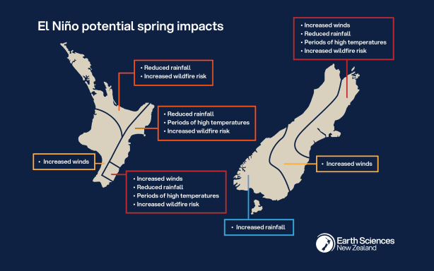
The expected effects of El Niño during spring will vary around the country. Supplied / ESNZ
Meanwhile, the eastern parts of the North and South Island could expect to see a warmer than usual spring, and "unusually dry" conditions, said Brandolino.
He said there would be elevated risks of wildfires in the eastern parts as the El Niño progressed and as the dry conditions met with high winds.
Brandolino said recent fires in Wanaka and Canterbury over the past week to 10 days showed the influence of El Niño already taking place, and there's concern that fires could spread quickly as winds became more persistent and the dryness became more pronounced as the El Niño progressed.
He also recommended that those in water reliant sectors - including farmers and people who rely on tank water, to start thinking about how to minimise the impact of the dry weather to come.
"It may take till October, November, or beyond, but the effects of dryness will eventually start to be realised - and we think that's most likely in northern and eastern parts of both islands, but especially the North Island," said Brandolino.
Brandolino said this El Niño would match the strongest seen in modern history - as the minimum.
He added that a more realistic alternative is that it becomes the strongest El Niño over the past 50-100 years.
However, Brandolino said while a record or near record El Niño made weather impacts more likely, it did not guarantee that there would be record weather impacts.