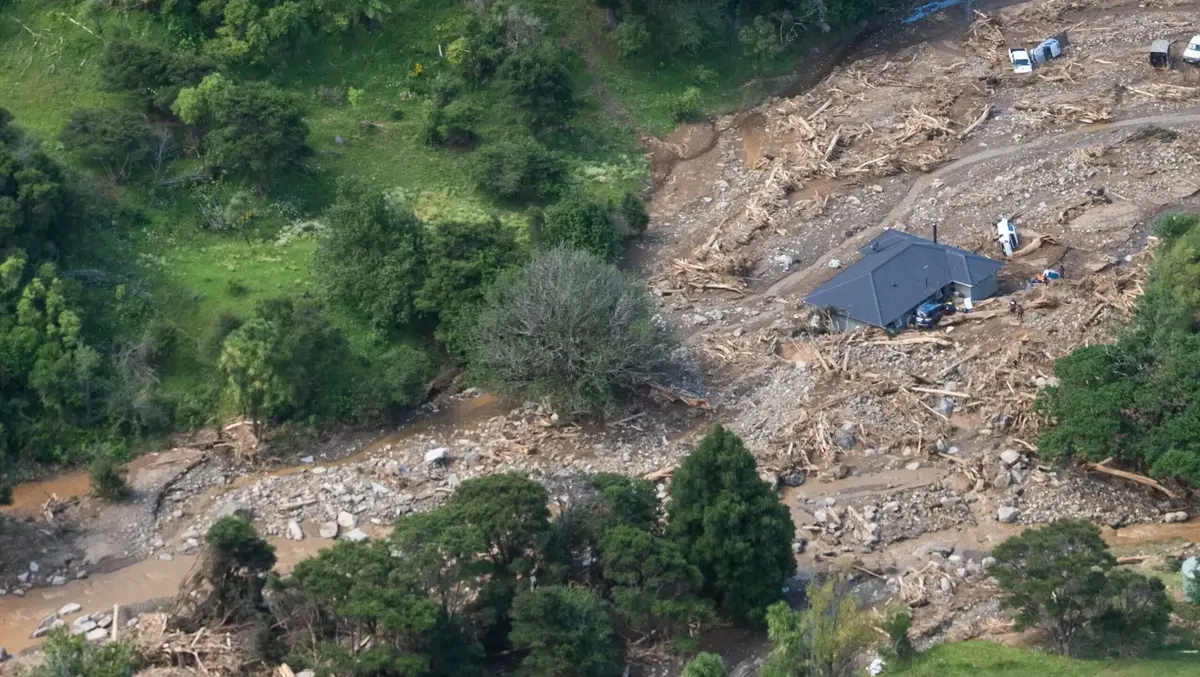
Managed retreat on the cards for long-term storm recovery on East Cape
Thu, 29th Oct 2026 (Today)Some East Cape communities could face relocation as Gisborne grapples with storm recovery.
Gisborne District Council's emergency management committee received reports on Wednesday outlining recovery work needed in Wharekahika/Hicks Bay, Onepoto Bay, Punaruku and the Wairenga Stream near Tokata Rd since January's Tropical Depression 5F.
Recovery manager Naomi Whitewood said the reports were commissioned to understand the storm's impacts and identify potential solutions.
Council principal scientist Dr Murry Cave led the project using a protect, adapt, retreat or avoid framework established by the Ministry for the Environment.
Both assessments concluded the January event was driven by landslide sediment and debris, and was a one-off flood that could be resolved with stream clearing and road repairs.
The assessments recorded 619 landslides across the Pukeamaru Range, including 183 in the Wairenga catchment.
Sediment and debris could continue moving for years.
Council noted communities held strong ancestral connections to the whenua, so decisions carry weight.
Wharekahika/Hicks Bay, Punaruku and Onepoto Bay
A Tonkin and Taylor report, supported by Massey University geomorphologist Professor Ian Fuller and risk specialist Professor Tim Davies, identified an ongoing threat to life in Hicks Bay, Punaruku and Onepoto Bay, where boulders, sediment and woody debris were carried through streams and rivers, causing flooding and property damage.
An area of concern was Punaruku, where 24 people were evacuated and one whānau had to be rescued from their rooftop.
The report suggested large structural protection works, such as stopbanks, should not be relied on and could worsen conditions downstream at the Te Araroa motorcamp and surrounding houses.
Short-term options included improved flood warnings, monitoring and community emergency management.
Planning controls, updated hazard modelling and mapping could help prevent further development in hazard zones.
The report also identified maintaining stormwater drainage near State Highway 35 at Onepoto Bay and addressing bridge alignments in Punaruku.
For the most exposed properties, managed retreat was identified as a long-term option, alongside bridge realignments in Punaruku.
However, the report did not identify which properties might need to relocate, who would be responsible for relocation or property acquisition, or how much the work would cost.
The central government co-funded Category 3 buy-out programme, due to expire in March 2027, has no equivalent for the January storm.
The report noted the Tāmaki Makaurau Recovery Office in Auckland had also been told central government would not support buy-outs based on pre-storm market values.
Whitewood said some whānau were considering leaving, while others were concerned about losing their only piece of whenua.
"We have whānau that are considering whether they need to leave. We have whānau that have decided that they want their whānau to stay in the area for the rest of their lives there, and then we have whānau that really have no idea what they need to do."
She said some landowners wanted to progress short-term solutions, particularly in Punaruku, while others needed more time and support to consider their options.
Councillor Rawinia Parata said the report outlined potential solutions but lacked clear next steps.
"It doesn't tell us who's responsible for supporting, navigating, implementing, engaging. It kind of goes halfway."
The findings needed to be considered alongside the communities' cultural and historical connections to the land, Parata said.
"It doesn't tell us anything about the history of the community, it doesn't tell us where the sites of significance are, it doesn't tell us how much it hurts to be told to move."
Whitewood said the report provided expert information for communities, iwi and hapū to consider, but did not assign responsibilities or prescribe solutions.
When asked by Parata, Whitewood said the report had not been peer-reviewed, but some landowners were seeking peer reviews independently.
Cave said an international peer review was planned. The report's completion had been delayed until findings from retired High Court Judge Paul Davison's external review into the Mauao landslide in Tauranga were released.
Engagement with local groups meant feedback about history and culture was taken into account and community action for long-term solutions was added to the report, he said.
The report did not determine what properties might need to relocate or the cost of works.
Wairenga Stream (Tokata Rd)
Wairenga Stream, near Tokata Rd outside Te Araroa, changed course in January and again in June, causing recurring flooding on farms, an orchard and nearby properties.
There was no current risk to life or affected public lifeline assets, so redirecting the stream for $50,000 to $75,000 was identified as a preferred option.
The work would require an engineered design, resource consent, agreement from affected landowners and funding.
The land involved was primarily Māori freehold land and adjoining properties.
The council assessment found the circumstances did not meet the threshold for emergency works under the Resource Management Act.
With no council budget or external funding available, the report recommended council support landowners through the consent process and help explore funding options.
Councillor Rob Telfer said the situation would set a precedent in the region, because redirection could happen in any gully in the community.
Telfer asked what resource consent and monetary boundaries were stopping the work from progressing as quickly as possible.
"The cost is falling on a small number of individual landowners, but we as a council can facilitate that process as much as possible. But we do not manage every single stream and river in the region. Quite a lot of land is private land, and so it is their responsibility to do that."
Whitewood said the review was critical information before moving to next stages, but meetings were planned with landowners to discuss obstacles.
Telfer asked if it would be possible in future to provide information and modelling for future events where work on private land could be undertaken as soon as possible.
Cave cautioned that each stream or river change was different and section 330 of the RMA restricted emergency works powers to specified authorities and operators.
Chief executive Nedine Thatcher Swann said clearer information about what work was permitted, who could undertake it and what support council could provide would help reduce reactive decision-making.
Councillors Telfer and Jeremy Muir moved the overall recovery report.